DHS
Science
Syllabus and Course Policies (Needs to be signed by parent and student)
Flinn Safety Contract (Needs to be signed by parent and student)
Our Planet's History
Here is where we will begin our semester-long exploration of the planet Earth. Each lesson has an associated PDF document, a bit of text here, and perhaps a video or simulator link. Use these resources to explore the concepts of Earth Science. By the end of this course of study, you should be able to explain in detail the processes at work on, above, and below Earth's surface.
WebLab- Simulating Relative Age in a Geologic Cross-Section (PDF)
One of the first concepts we will explore in Earth Science is the idea of "relative age," also called "relative dating." Since we are learning about Earth History in this unit, it is a valuable skill to be able to look at rock layers and determine what events happened to create them, and what order. The weblab above helps you to explore the concept of relative age by creating geologic cross-sections and using them to figure out in what order the layers were made.
-
Click the following link for the interactive Visible Geology simulator: https://app.visiblegeology.com/profile.html
-
Click the following link to see a helpful screencast on how to use this simulator while following the worksheet: https://youtu.be/kBQpumb0M8g
https://app.visiblegeology.com/profile.html
Geological Story Time- Using "Stories" to Understand Geologic Cross-Sections (PDF)
Now that you have some idea how to tell a story based on a geologic cross-section, it is time to amp up the level of challenge. Here you will learn how to read a "story" of an area's rocks. Then you will draw your own cross-section based on the order of events. There are 8 examples in the document above. Try them, then check the key to see how you did!
-
Click the following link to see a helpful screencast about how to practice creating cross-sections based on geological stories: https://youtu.be/vUQHWi0x5So
The Importance of Layers: Not Just for Cakes (PDF)
What can rock layers tell us about how the planet and its features formed? Look at the examples and decide how the position of rock layers indicates the order in which they were laid down. Are there any "rules" you can come up with? Are there any examples of violations of these rules?
-
Screencast- Click the following link to see how we can use geological layers to tell the "story" of the rocks: https://youtu.be/wOqrEPJN0II
https://parade.com/334610/parade/how-to-make-a-rainbow-layer-cake/
WebLab- The Grand Canyon: How did it form? (PDF)
Now that you have some experience with using rock layer features to determine a region's geological history, let's put our learning to practical use. Let's take a look at the Grand Canyon's geological cross section to tell the story of its creation. This weblab will help you to do that.
-
Click the the following link for the interactive Grand Canyon simulation: https://www.classzone.com/books/earth_science/terc/content/investigations/es2906/es2906page01.cfm
*Note: This simulation runs on Flash. If your browser does not support Flash, either change the browser's security settings or use a different browser.
http://www.lebsack.net/canyons/grand-canyon-national-park/
Geological Dating WebLab: Beyond Carbon Dating (PDF)
By now you should be an expert in determining the order of rock formation based upon the law of superposition and how disturbances can violate this law. But have you ever wondered how geologists are able to determine the age of a rock layer in years? This weblab will show you how to do radiometric dating with different elements to determine the time of past geological events.
-
Click the following link for the interactive radiometric dating simulation: https://phet.colorado.edu/en/simulation/legacy/radioactive-dating-game
*Note: If your browser asks whether you want to allow run or keep the program, indicate yes.
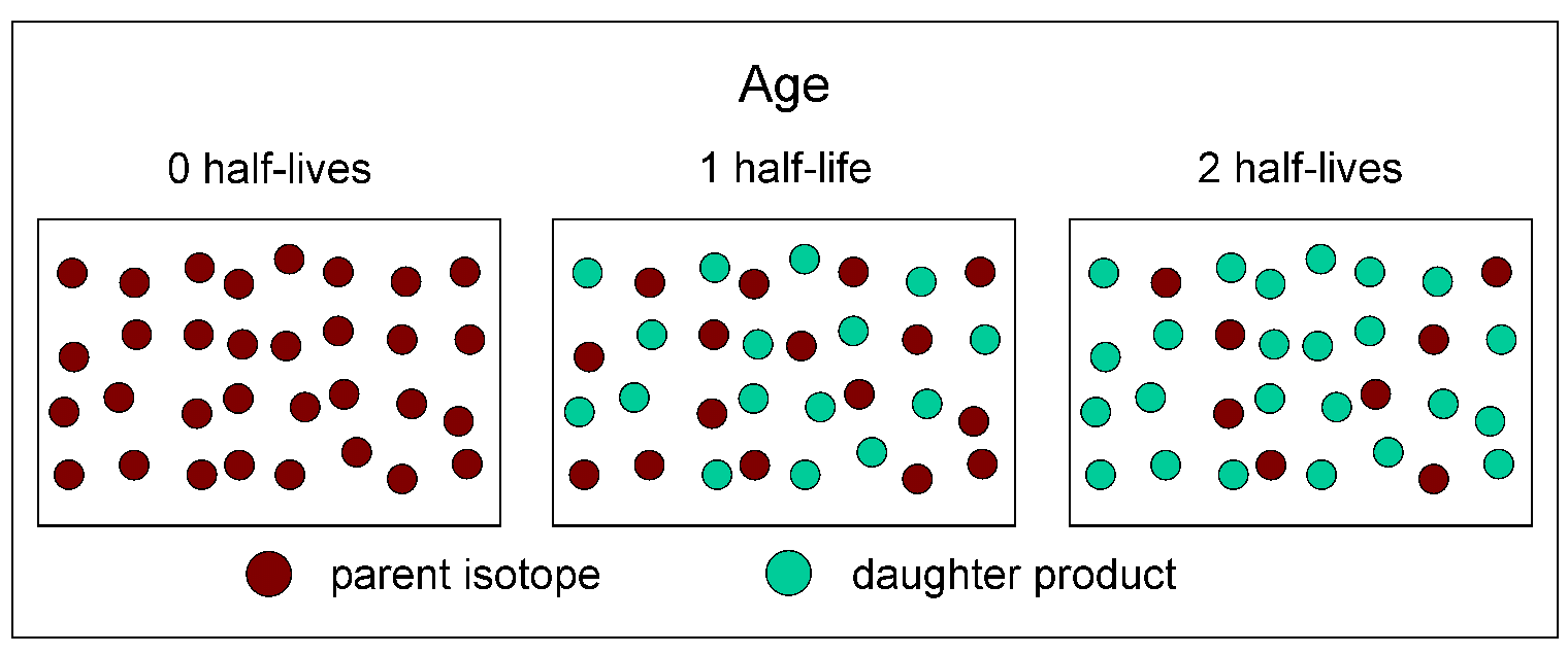
Radiometric Dating and Half-Life: Developing and Testing Models (PDF)
Now that you have some sense of the behavior of radioactive elements and how to use them for dating rocks, let's develop our models of half-life and begin to create mathematical representations for this phenomenon.
-
Click the following link for an excellent video describing the concepts behind radiometric dating of igneous rocks: https://www.youtube.com/watch?v=oe45GegJUvM
https://courses.lumenlearning.com/cuny-lehman-geo/chapter/radiometric-dating-methods/
Radiometric Dating Calculation Practice (PDF)
By now you should be able to see what half-life is. "Half-life" is the amount of time (often in years) that it takes for 50% of a radioactive sample to decay into daughter isotopes. The document above gives you several opportunities to practice the skill of determining the age of a sample with simple mathematical procedures.
-
Click here to see a key for the radiometric dating problems above.
Index Fossils: A Super-Lit Sensation with a Boring Name (PDF)
With radiometric dating, we can estimate (at least to within a few percent) how many years have passed since an igneous layer or intrusion was created. But what if no igneous intrusions or lava flows are present? This document walks you through some of the logic and art of using "index fossils" to date layers of rock, even if you don't have igneous rocks around.
http://scotdir.com/other/how-to-determine-the-age-of-a-fossil
Using Absolute Age to Make Use of Index Fossils (PDF)
As you learned in the previous lessons, radiometric dating can be used to determine the age of an igneous rock. If a geologic cross-section includes igneous rocks, you can date them with radiometric dating. This means that you can develop a simple timeline for a cross-section, including the approximate the age of certain features! To explore and sharpen this skill, see the document above on how to use radiometric dating, and try to create some timelines for each cross-section.
-
Click here to see a key for the index fossil problems above.
Guiding Questions for Earth History Summative Assessment (PDF)
Now that you have had a variety of learning experiences to understand our planet's history, it is time for a summative evaluation of your learning. Use the above document as a guide for your studies as you prepare for the Earth History summative assessment.
Earth's Processes
Paleo-Puzzle: Applying Your Skills to Solve an Ancient Mystery! (PDF)
In this ill-defined problem, you are asked to figure out what the ancient Earth looked like. To accomplish this task, you will have to use your skills in the law of superposition, intrusions, radiometric dating, and using index fossils. You have a set of geological cross-sections from a variety of locations on Earth, and you must use these to determine what the ancient Earth looked like far in the past!
-
For a shortcut on the radiometric dating parts, you can use the following half-life calculator: https://www.calculator.net/half-life-calculator.html
In the Everest Redux work, you saw that the rocks of Mount Everest- particularly the schist and marble- were formed by metamorphism. This is when huge pressures smash rocks and change their crystal structure. But what kinds of large-scale, regional activities cause such huge pressures in the rocks of Everest? In this simple observational lab, you will start to investigate why the tectonic plates of Earth move horizontally.
-
Click the following link to see a helpful explanatory video on the movement of tectonic plates: https://youtu.be/6slfJ4eOL5U
Plate Movement WebLab- What Can Happen at Plate Boundaries? (PDF)
In the pie tin convection lab, you observed that heating reduces a fluid's density, and this reduction in density will produce a buoyant force on the fluid, which causes it to rise. When the Earth's mantle rises and flows against the bottom of a crustal plate, the force imparted upon the plate drags it horizontally. This is the basis of tectonic plate movement. But what happens at different plate boundaries when tectonic plates interact? In this easy-to-learn weblab, you will investigate the different boundary types and identify the surface features you can use to tell the boundaries apart.
-
Click the following link to access the interactive plate movement weblab: https://phet.colorado.edu/en/simulation/legacy/plate-tectonics
Tectonic Mapping Data Lab (PDF)
In the plate movement weblab you investigated how different plates interact. You saw that certain plate boundaries resulted in volcanoes, some resulted in mountains, some resulted in earthquakes, and some resulted in new crust. In this tectonic mapping lab, you will use global maps of Earth's crust and the features we find there. You will come to conclusions about the movements of different tectonic plates by observing the surface features.
-
Maps of tectonic data (pending)
Slinky Lab- How Can We Investigate the Earth's Structure? (PDF)
By now you are an expert in tectonic plate movement. You have observed what happens at the different plate boundaries and why they occur. However, what we have not done yet is explore the interior of the Earth and how it is structured. Now, contrary to movies like this one, we cannot visit the inside of the Earth! So how can scientists ever figure this out? To conduct this lab you will need a slinky, a meter stick, and perhaps an iPhone or other smartphone with a slow-motion camera. You will investigate the kinds of variables that influence the behavior of waves, and you will begin thinking of how you will extend this investigation to find out how Earth's interior is structured.
"Hang Ten, Bro!" A Gnarly Investigation of Waves in the Earth (PDF)
In the slinky lab you began to investigate waves. You might have found that a wave's amplitude (and therefore its energy) does not seem to influence its velocity, nor does its wavelength. If you explored transverse and compression waves and compared them, you might have found that these different wave forms sometimes move at different velocities. How can we use this? In this weblab, you will explore how different waves move inside the Earth's interior. You will also try to characterize two important waves based on their velocity and how they refract inside the planet.
-
Click the following link to see some scary footage of earthquakes: https://www.youtube.com/watch?v=_hUGhoB2FnM
-
Click the following link to access the interactive earthquake wave weblab: http://ds.iris.edu/seismon/swaves/
-
Click the following link to see a helpful screencast on how to use S waves and P waves to infer the Earth's structure: https://youtu.be/8Q18MOl3Zmw
Guiding Questions for Earth Processes Summative Assessment (PDF)
Now that you have had a variety of learning experiences to understand the processes at work on Earth, it is time for a summative evaluation of your learning. Use the above document as a guide for your studies as you prepare for the Earth Processes summative assessment.
Earth's Climate Systems
What Climates are Where? A Global Climate Investigation (PDF)
In the previous unit you learned about the processes taking place under the surface of our planet. Now it is time to take a look at the processes taking place above it. Let's begin by making observations, inferences, and questions about Earth's climate systems. In this investigation, you will use an online climate tool to investigate some patterns, trends, and cycles in Earth's climate systems.
-
Click the following link to access the interactive climate tool: https://www.biointeractive.org/classroom-resources/biomeviewer
-
Click the following link to see a helpful screencast explaining how to use the interactive climate too: https://youtu.be/ZrLBfEi_i4k